Photo by Peter Johnson Images
DISASTERS HAPPEN. BE PREPARED
Preparing in Advance: A Key to Survival
In our region, various natural hazards pose potential threats to our community. While flooding and bushfires are the most common occurrences, we must also consider the possibilities of heatwaves, tsunamis, storms, east coast lows and earthquakes. The best way to navigate these challenges is through proactive preparation.
By taking action before disaster strikes, we can significantly increase our chances of survival and minimise the impact on our lives.
Make sure you:
- Know your risk by staying up to date with the latest information on potential hazards in the area.
- Create an emergency plan and decide in advance if you will evacuate or shelter in place.
- Follow the instructions provided by emergency services including where the evacuation centre is located. This will be determined by emergency services and is based on the risk presented by a particular hazard. It may not be the same location as a previous incident or event.
- Prepare an emergency kit for sheltering at home and evacuation kit to take with you if you have to evacuate.
- Decide what you will do if an emergency happens, and you are in a different location to your family (work, school, shopping).
- Take measures to safeguard your property against potential damage.
- Stay connected with your neighbours, friends, community organisations and ICOPE.
- Get assistance from SES if you have damage to your home, call 132 500.
- Know how and when to call 000 or 112 from your mobile.
Remember, preparedness is an ongoing process. Regularly review and update your emergency plans and supplies to ensure they remain relevant and effective. Stay informed about changes in your local area and participate in ICOPE community drills or training exercises whenever possible.
Floods: Unravelling the phenomenon of floods
A flood is a powerful and potentially destructive natural event that occurs when an area becomes overwhelmed by an excessive amount of water.
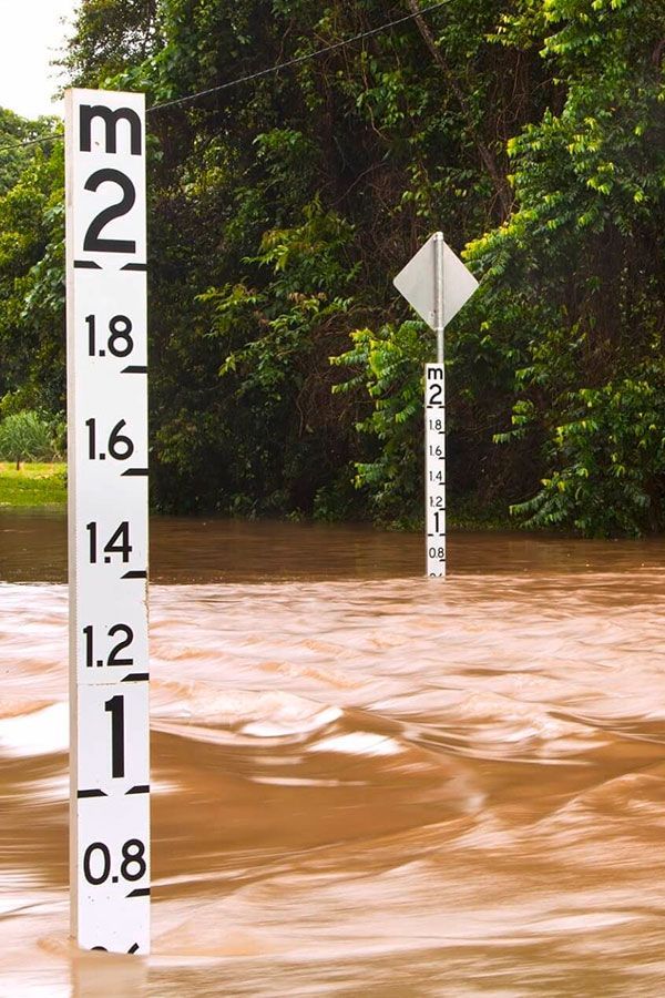
Like many other coastal areas, Iluka can be susceptible to flooding, particularly during periods of heavy rainfall. Flooding can occur due to a variety of factors such as intense rainfall, river overflow, storm surges, or a combination of these events.
When heavy rainfall exceeds the capacity of rivers or drainage systems to handle the water, it can result in the inundation of low-lying areas in Iluka, including residential and commercial areas. Floodwaters can cause damage to infrastructure, homes, and property, as well as pose risks to human safety. Additionally, floods in Iluka often lead to road closures (particularly Iluka Road), disruption of transportation, and interruption of essential services such as electricity, mobile network and food supply.
To manage flood risks, there are flood warning systems in place to monitor weather conditions, river levels, and issue timely alerts to residents. It is important for people living in low lying flood-prone areas in Iluka to stay informed about weather updates, evacuation plans, and follow the guidance provided by the SES and sometimes the RFS. If it’s flooded, forget it and never enter flood waters. The major cause of death during floods is from people entering or travelling through floodwater. This includes driving, riding and walking through floodwater and children playing in floodwater.
Through preparedness, awareness and community cohesion, we can develop greater resilience and emerge stronger when the flood waters recede.
If you’re in an area that could be affected by flooding, it's important to be prepared. Watch this video to gain a greater understanding of preparing for a flood.
For more information on flood preparedness, response and recovery visit the SES website
Click the button to download a checklist for before, during and after a flood
Unmasking the fiery fury: Demystifying bushfires
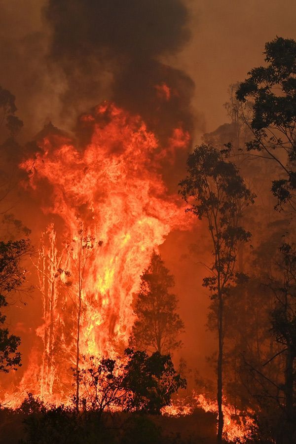
A bushfire is a fierce and formidable force of nature that demands our utmost respect and understanding. Iluka and the surrounding villages are highly susceptible to bushfire.
At its core, a bushfire is an uncontrolled fire that spreads rapidly through vegetation in areas such as forests, woodlands, or grasslands. It is typically fuelled by dry vegetation, intense heat, and strong winds, creating a devastating combination that can quickly transform a tranquil landscape into a fiery inferno.
The origin of a bushfire often lies in the convergence of certain factors. The perfect storm is created when dry conditions prevail, leaving vegetation parched and susceptible to ignition. Add to that a spark, whether from lightning, human activity, or other sources, and the stage is set for a potentially catastrophic event.
As the fire takes hold, it can exhibit different behaviours and patterns, depending on various factors such as fuel availability, topography, weather conditions, and the intensity of the ignition source. Bushfires can range from slow-burning ground fires that creep along the forest floor to raging infernos that leap through treetops, creating a crown fire.
The impacts of a bushfire are far-reaching and multifaceted. They pose immediate risks to life and property, as well as long-term ecological and environmental consequences. The intense heat can cause structures to ignite and engulf entire communities in flames, leading to tragic loss of life and displacement. The smoke generated by bushfires can blanket vast areas, posing significant health risks to individuals, particularly those with respiratory conditions.
The ecological impacts of bushfires are equally profound. They play a vital role in the renewal and regeneration of ecosystems, allowing certain plant species to thrive. However, severe and frequent bushfires can disrupt the delicate balance of ecosystems, destroy habitats, and have long-lasting implications for biodiversity.
By demystifying the nature of bushfires, our community can empower ourselves to take action. Iluka can emerge stronger and more prepared to protect ourselves, our community, and the natural beauty of Iluka if we arm ourselves with knowledge and build a resilient shield against the fury of a bushfire.
Do you know how to reduce the hazards around your home in case of a bushfire? Do you know the strategies to protect your home, or the best and safest way to evacuate? Watch this video to gain a greater understanding of preparing for a bushfire.
For more information on bushfire preparedness, response and recovery visit the
RFS website
Click the button to down a checklist for before, during and after a bushfire

Unveiling the scorching spell: Decoding heatwaves
A heatwave is a prolonged and intense period of excessively hot weather when maximum and minimum temperatures stay unusually high for three or more days. Temperatures in NSW are increasing because of climate change. Climate change will also mean that we have more heatwaves, and they will be hotter and longer than they are now. While Iluka fairs better than many other regional areas because of our coastal location, we must be prepared to navigate heatwaves through developing our understanding and preparedness.
At its core, a heatwave is characterised by a prolonged period of unusually high temperatures that surpass the average climate norms for a particular region. The duration and intensity of a heatwave can vary, lasting from three days to several weeks, and often encompassing a vast area.
The primary cause of a heatwave is the dominance of a high-pressure system that traps hot air in a specific area, preventing it from dissipating and leading to a rapid rise in temperatures. Combined with other factors such as clear skies, limited cloud cover, and a lack of rainfall, heatwaves can intensify, pushing the mercury to unprecedented heights.
The impacts of a heatwave extend beyond the discomfort of sweltering temperatures. They can pose serious health risks, particularly for vulnerable populations such as the elderly, young children, and individuals with pre-existing medical conditions. Heat-related illnesses, including heat exhaustion and heatstroke, become a major concern as our bodies struggle to cope with the excessive heat and strain.
Furthermore, heatwaves can strain infrastructure and disrupt daily life. Overburdened power grids struggle to meet the demands of increased air conditioning usage, leading to potential blackouts. Agricultural and ecological systems suffer as well, with crops wilting, water sources drying up, and wildlife struggling to find relief.
To combat the scorching impact of heatwaves, preparedness is key. Stay informed about weather forecasts and heatwave warnings in your area. Take necessary precautions to protect your health and that of your loved ones, such as staying hydrated, seeking shade, and avoiding prolonged exposure to the sun during peak heat hours. Check on vulnerable individuals in the community and ensure they have access to cool spaces or assistance if needed.
Heatwaves kill far more people than natural hazards like bushfires, cyclones and floods. Adequate preparation is essential, especially for people at high risk. Watch this video to gain a greater understanding of preparing for a heatwave.
Click the button to download a checklist for before, during and after a heatwave

Unleashing the wrath of the sea: Demystifying tsunamis
At its core, a tsunami is a series of powerful ocean waves that are generated by seismic activity beneath the Earth's surface. Most commonly, tsunamis occur as a result of undersea earthquakes, but they can also be triggered by volcanic eruptions, landslides, or even the impact of a meteorite. When these forces of nature are unleashed, they can cause the entire body of water above to become displaced, creating a surge of enormous waves that spread across the ocean.
Tsunamis differ from regular ocean waves in their sheer size, speed, and destructive potential. While normal waves are driven by wind or tidal forces, tsunamis can travel at incredible speeds across vast distances, reaching speeds of up to hundreds of kilometres per hour. As they approach the coastline, their energy compresses, causing the waves to increase in height and unleash their disastrous force upon the land.
The impacts of a tsunami can be catastrophic and far-reaching. The initial wave may not be the largest, as subsequent waves can follow for several hours or even days, wreaking havoc on coastal areas. These powerful surges of water can inundate low-lying regions, erode shorelines, and sweep away everything in their path. Buildings, infrastructure, and human lives are at great risk as the force of the tsunami collides with the shore.
While Australia's eastern coast is situated along the 'Pacific Ring of Fire,' a region known for its high potential for tsunamis, due to the absence of plate boundaries in close proximity to the coast, we usually receive sufficient warning for such events. Australia also has a well-developed monitoring system in place, providing us with the capability to detect and track tsunamis. Nevertheless, our continental shelf edge can be susceptible to underwater landslides, which have the potential to generate tsunamis with much shorter warning times, directly impacting our coastline.
It is important to be prepared in case a tsunami strikes. Learn how to protect yourself and your home with this short video.
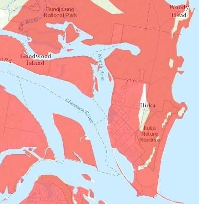
While the likelihood of a land-threat tsunami on the east coast of Australia is low it is important to know where you would have to move to higher ground in the event of a land-threat tsunami. The NSW State Emergency Service (NSW SES) has released maps showing evacuation areas in the event of a land-threat tsunami.
Click this link to access the SES tsunami evacuation map - https://www.ses.nsw.gov.au/tsunamisafe/evacuation-map/tsunami-evacuation-map/
For more information on tsunami preparedness, response and recovery visit the SES website.
Unleashing nature's fury: Unravelling storms
A storm is a powerful and dynamic display of nature's raw energy that commands our attention and instils a sense of both awe and caution.
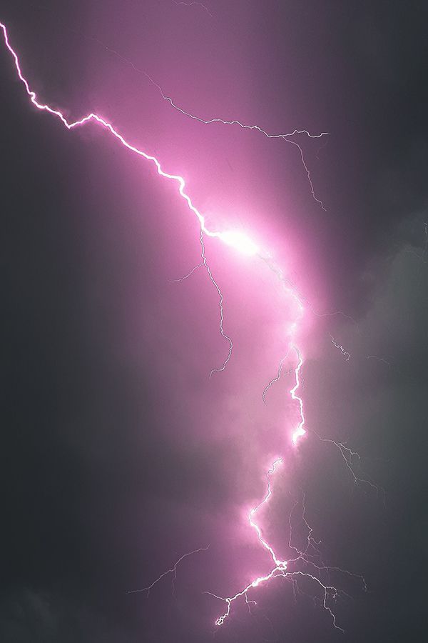
At its core, a storm is a complex weather phenomenon characterised by a disturbance in the Earth's atmosphere. It is often marked by a combination of intense wind, precipitation, and sometimes even electrical activity.
Thunderstorms, for example, are born from unstable atmospheric conditions where warm, moist air rises rapidly, forming towering cumulonimbus clouds. Thunderstorms usually are a combination of thunder and lightning, as well as heavy rain, hail, and strong winds. They can be brief and localised or last for hours, unleashing their power and producing a symphony of sounds.
The impacts of storms can be far-reaching and diverse. They can cause damage to infrastructure, homes, and property through strong winds, flooding, or falling debris. Storms can disrupt power grids, communication networks, and transportation systems, leading to widespread inconveniences and potential dangers. In some cases, storms can also result in loss of life and displacement of communities.
Community cohesion and support are vital during storms. Engage with your neighbours, local organisations, and emergency response agencies to foster a culture of preparedness and mutual assistance. Support vulnerable individuals in your community, such as the elderly or those with disabilities, and be ready to lend a helping hand when needed.
Want to prepare your home this storm season? This short video by GIO Insurance gives some practical hints and tips to get storm ready
For more information on storm preparedness, response and recovery visit the SES website. Link: https://www.ses.nsw.gov.au/disaster-tabs-header/storm
Click the button to download a checklist for before, during and after a storm

Unveiling the east coast low: Deciphering a weather system
An east coast low is a meteorological phenomenon that plays a significant role in shaping weather patterns along the east coast of Australia.
An east coast low, refers to a low-pressure system that typically develops along the south-eastern coast of Australia. It is characterised by an area of low atmospheric pressure, accompanied by cyclonic or counter clockwise rotation of air.
These weather systems often originate from the Tasman Sea or the Coral Sea and can be fuelled by the temperature contrast between the warm ocean waters and cooler air masses moving across the region. East coast lows are more prevalent during the cooler months, generally from autumn to spring, but can occur at any time of the year.
The impacts of an east coast low can vary depending on its intensity, size, and proximity to land. They are known for bringing heavy rainfall, strong winds, and rough seas to the affected areas. These weather systems can lead to localised flooding, coastal erosion, and significant disruptions to transportation and outdoor activities.
Preparing for an east coast low involves staying informed about weather forecasts and warnings issued by local authorities and meteorological agencies. It is important to have emergency plans in place, including strategies for dealing with heavy rainfall, potential flooding, and strong winds. Securing loose items, clearing gutters and drains, and avoiding unnecessary travel during severe weather conditions are all part of being prepared.
East coast lows often bring damaging weather conditions. This video explains how they form, including how they differ from tropical cyclones, and why they can be dangerous.

Newcastle Earthquake 1989
Unveiling the siesmic power of the earth: Understanding earthquakes
New South Wales, especially Iluka is not known for frequent or significant seismic activity compared to other regions around the world that are located along major fault lines. However, earthquakes can still occur in NSW and possibly Iluka, albeit less frequently and with lower magnitudes.
The Australian continent sits on a tectonic plate that is relatively stable compared to other regions. However, the continent is not entirely free from geological activity. The eastern part of Australia, including NSW, is situated near the boundary between the Australian Plate and the Pacific Plate. This boundary is known as the Pacific-Australia plate boundary.
While most earthquakes in NSW are generally of low magnitude and go unnoticed by people, larger earthquakes can occur occasionally. The most notable earthquake in recent history in NSW was the Newcastle earthquake in 1989. It had a magnitude of 5.6 and caused significant damage and loss of life in the city of Newcastle.
Earthquakes occur when there is a sudden release of energy along a fault line, resulting in the shaking of the Earth's crust. In NSW, earthquakes can happen due to the interaction of the Pacific and Australian tectonic plates. However, the frequency and magnitude of earthquakes in the region are relatively low compared to areas like New Zealand or the Pacific Ring of Fire.
Click the button to download a checklist for before, during and after a earthquake